
Mt Rohr Hike: the Unexpected Discovery. Hard yet Absolutely Rewarding!
Discover the Mount Rohr hike near Pemberton, British Columbia – a hidden gem trail leading to the stunning Rohr Lake and challenging Mt Rohr summit.
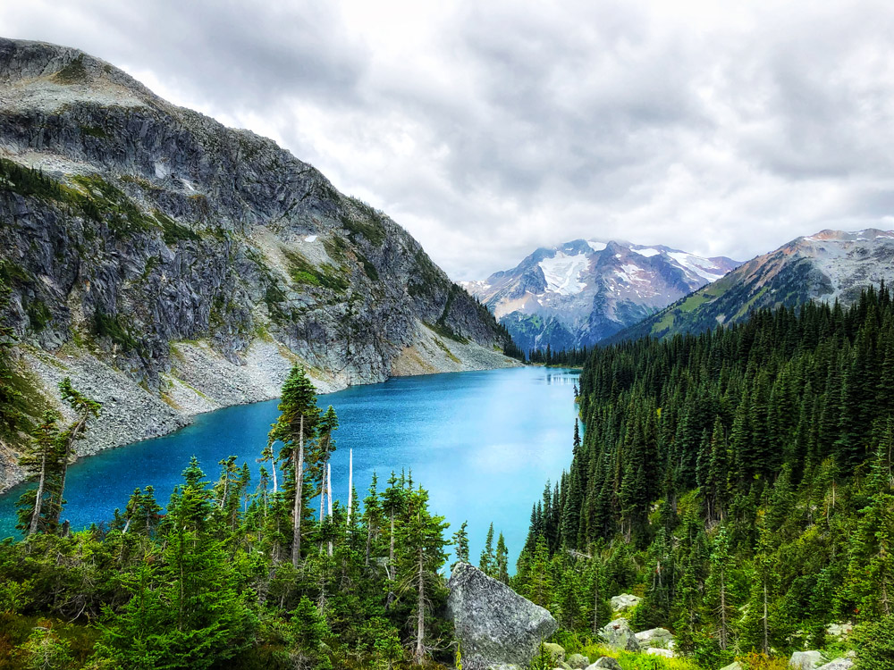
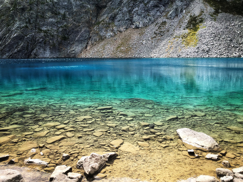
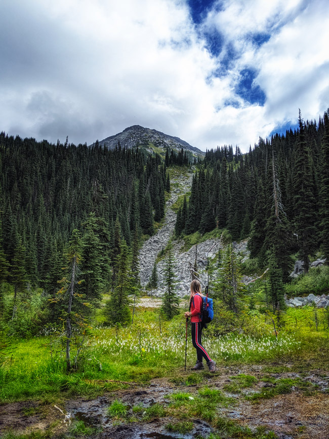
Mt Rohr hike is one of the lesser-known trails in Pemberton near Whistler British Columbia, and, although quite challenging, it does offer incredible views and is absolutely worth exploring. The stunning alpine lake with turquoise colored waters that you encounter along the way to the summit – Rohr Lake – is as beautiful as the famous Joffre Lakes not too far away. In this post, we share our own outdoor adventure experience hiking Mount Rohr, directions to trailhead and trail guide, advice on preparation, and hiking safety tips.
***This post may contain affiliate links and we may earn compensation when you click on the links at no additional cost to you. All product recommendations and feedback are ours and based on personal experience. Please refer to our Disclosure Policy.
Quick Links:
.
.
About Mount Rohr
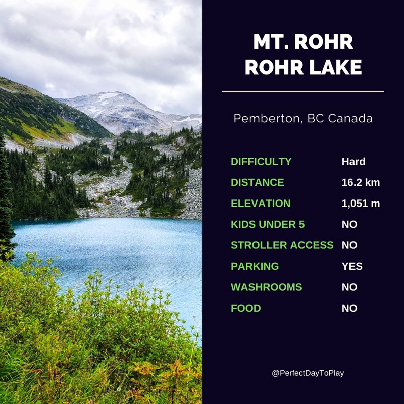
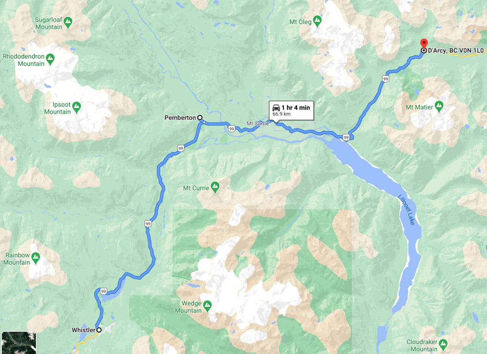
Mount Rohr is located about 30km east of Pemberton, British Columbia Canada, just along highway 99. Its summit peaks 2,423 meters (7,949 ft) into the sky.
Geographically, Mt. Rohr is located within Duffey Lake Provincial Park – it forms its western border and is the highest point. Yet access to Mt Rohr peak and Rohr Lake hike is on the other side – the east side.
In fact, Mt Rohr trailhead is just a few kilometers away from the famous Joffre Lakes, yet very few people know about this gorgeous hike. If you came to hike Joffre Lakes coming from the Lillooet direction, you might have unknowingly passed Mt Rohr trailhead many times.
The mountain was named after Rev. Victor Sebastian Rohr (1873-1965), who was a missionary to the First Nations people in the region for over 40 years.
The name – Mt Rohr – was officially established on April 21, 1966, by the Geographical Names Board of Canada.
.
Tips for Mt Rohr & Rohr Lake Hike
.
No Booking Required!
Since COVID pandemic unravelled in British Columbia, BC Parks have closed off many Parks, and have introduced significant restrictions on use of others.
Just like that Joffre Lakes Provincial Park was closed due to the COVID pandemic back in April 2020, and still remains closed to the public at the time of this writing. Another famous park near Whistler – the Garibaldi Provincial Park – now requires a reservation that has to be done at 6:00 am the morning of your anticipated adventure. These reservations can be made at the BCParks website, and are gone quickly.
Mount Rohr on the other hand is a lesser-known trail. It is also not officially a “Park” and therefore does not have BC Parks restrictions on use. You are still required to follow the rules of outdoor social distancing.
.
…oh and what I love about Mt Rohr being a “not Park” – there are no restrictions on flying a video drone!
.
Quick Facts
There is a detailed trail description within my favourite AllTrails mobile app.
Here is the link to the exact route we have taken: Rohr Mountain Via Marriot Basin Trail.
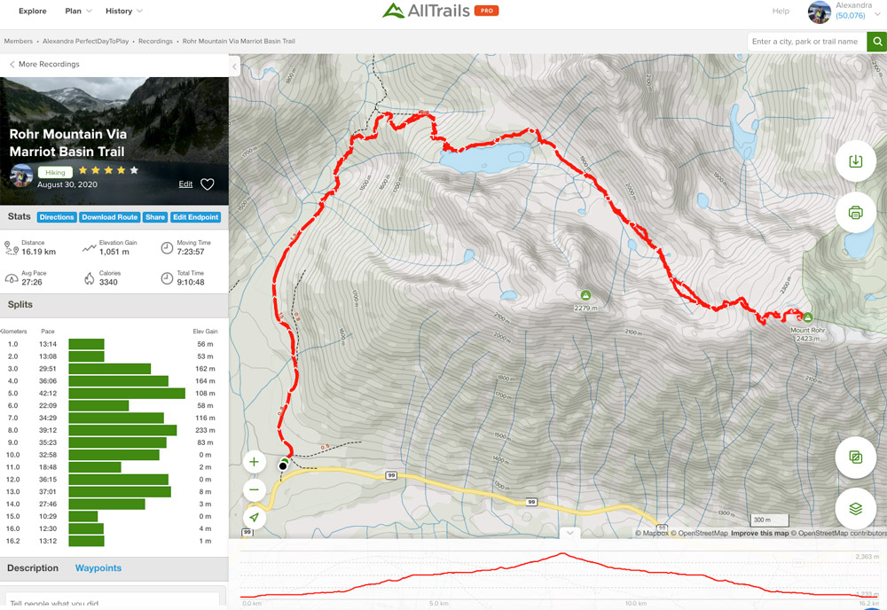
Hiking Mt Rohr is not an easy task. You should plan all day.
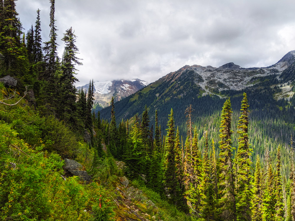
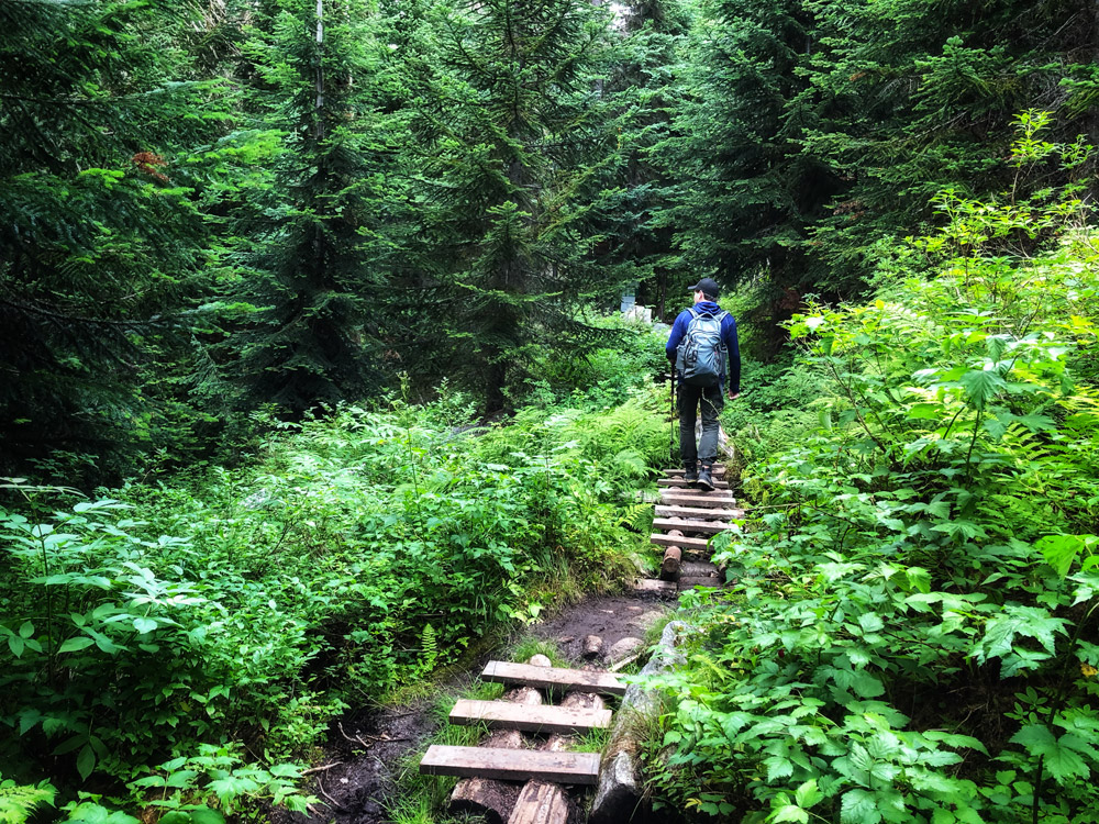
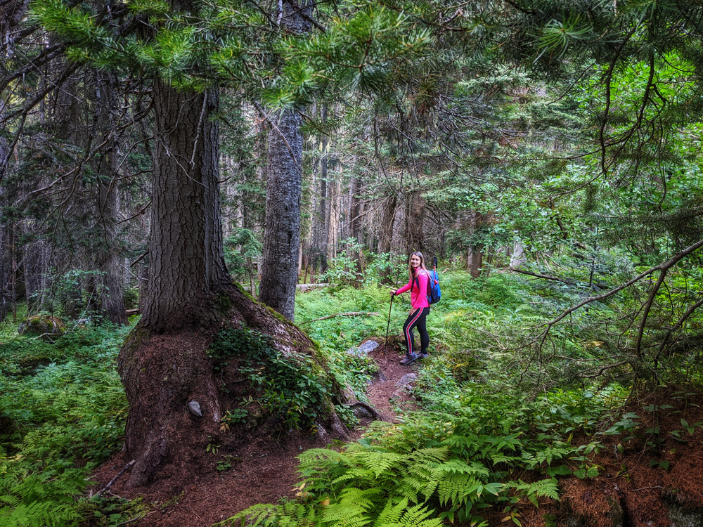
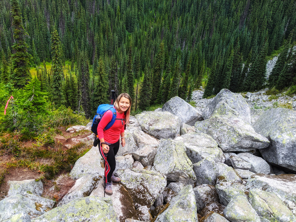
The trail starts off as a muddy forest path.
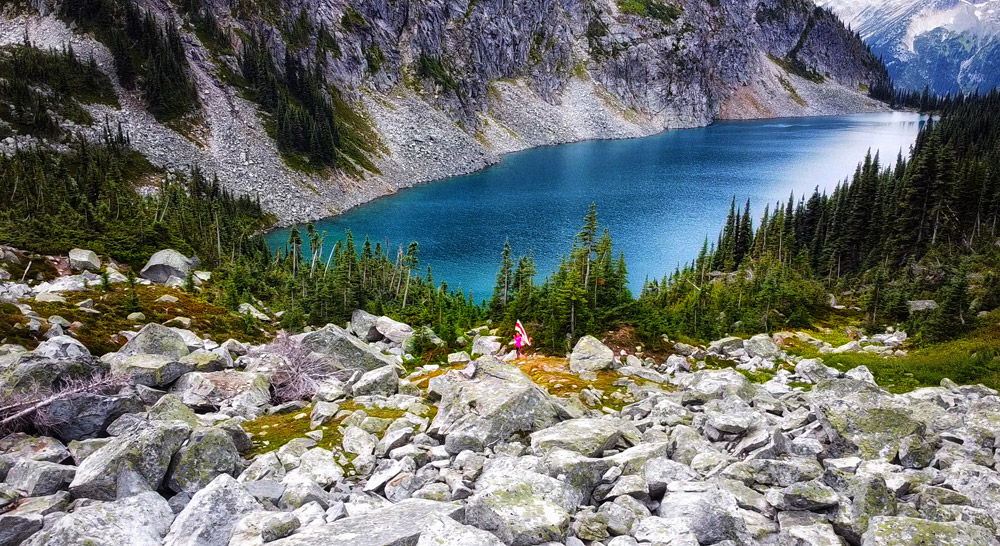
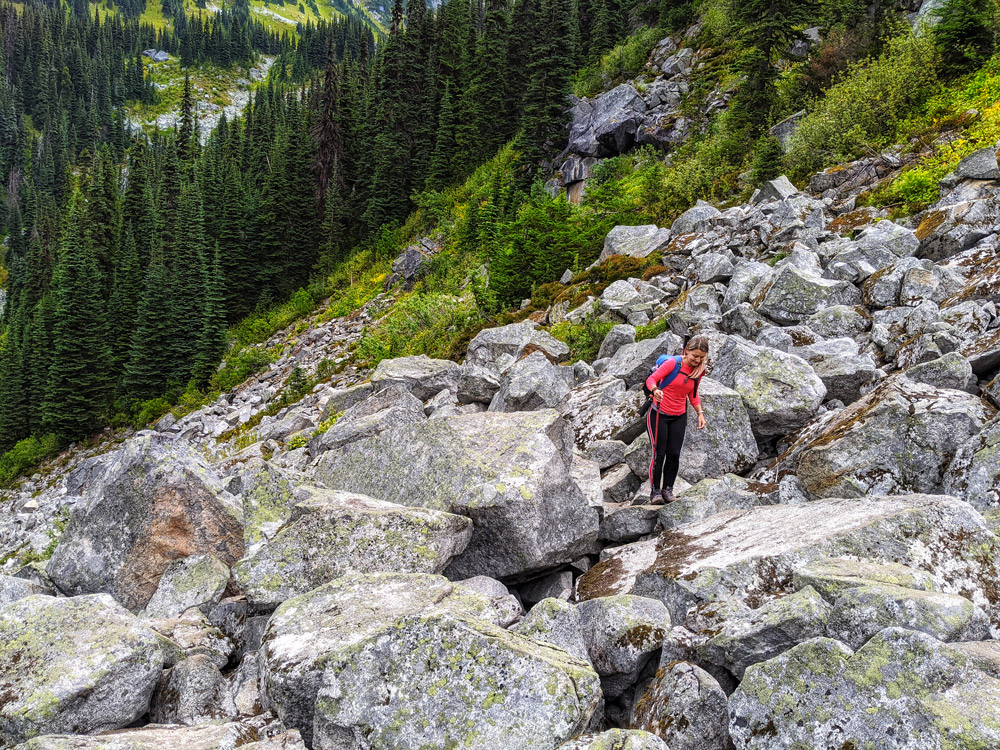
The first 1.5-2 hours of the hike will take you to the waterfall boulder wall where you will have to climb up a very steep and dangerous slope to get to Rohr Lake. The waterfall was almost completely dried out in August when we visited, so it was somewhat easier I guess. Still, it took us about 30 min to get all the way up.
.
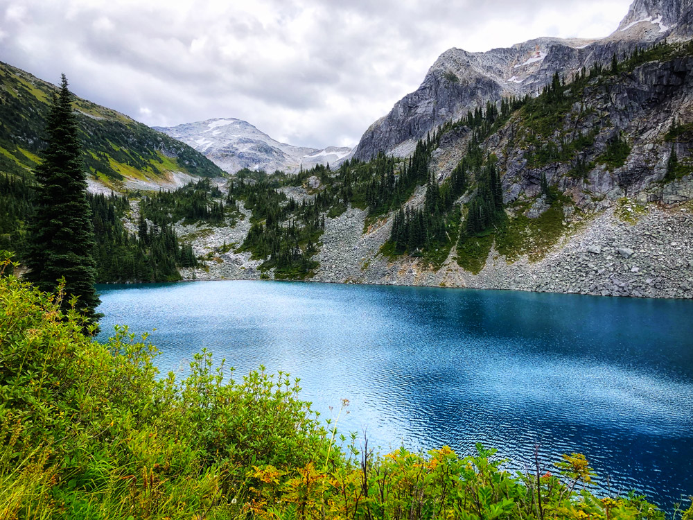
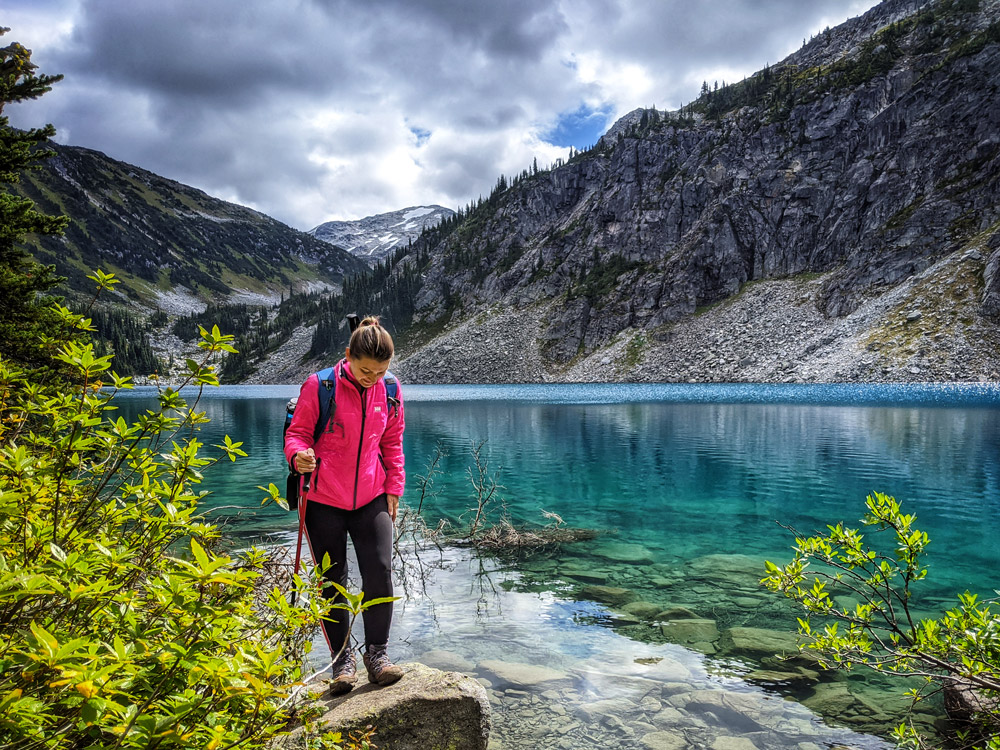
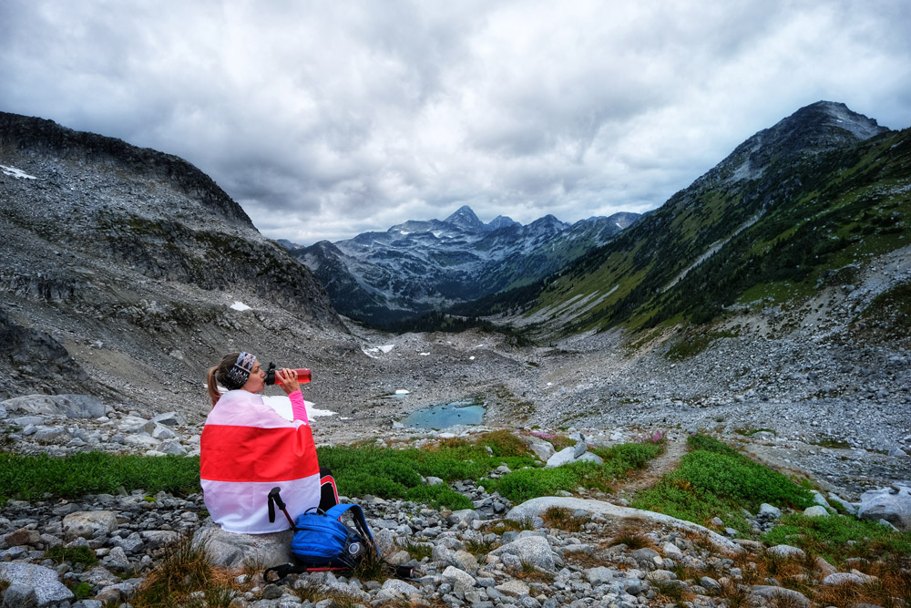
Once you get to Rohr Lake, you can relax a bit.
The water of Rohr Lake is absolutely stunning turquoise! I am naturally inspired and amazed a the color of British Columbia Glacier lakes. Other British Columbia lakes you can check out are: Joffre Lakes, Miller Lake at Mt. Revelstoke, Harrison Lake as seen from Sandy Cove beach trail, Mystery Lake at Mt. Seymour – the watercolors are AWE and absolutely Instagram-perfect!
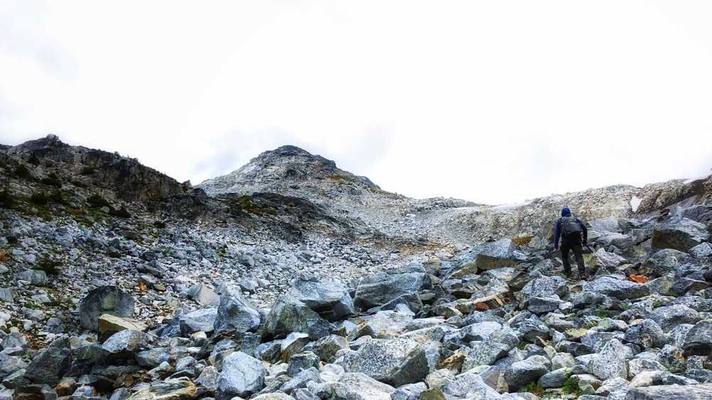
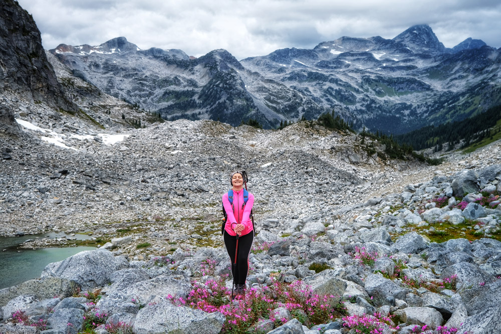
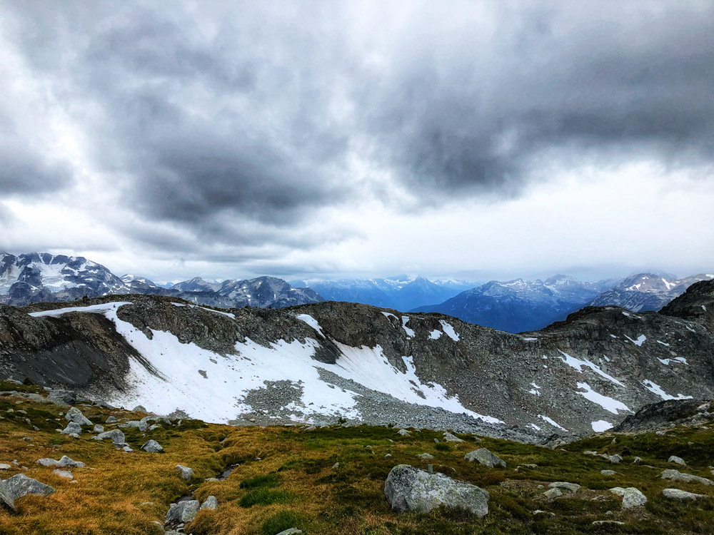
If you decide to proceed to conquer Mount Rohr Summit, be prepared for another 2.5 hours of grind.
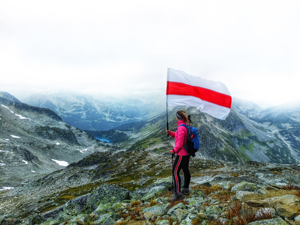
Once you reach the Mt Rohr Summit, however, the view is simply stunning! It's a 360 degree look-around. We weren't so lucky with the weather however, and we could only imagine the blue sky, still – breathtaking!
.
.
Planning For Your Hiking Adventure
The best time to hike Mount Rohr peak would be from mid-August to September before the rainy season starts. Even at this time, when most of the snow in the mountains is already gone, you will find parts of the trail are quite muddy. Therefore good hiking boots are a must.
We absolutely do NOT recommend doing the hike with kids under 10. Even if your child is older, it may be quite hard for them, as there is a lot of scramble throughout the hike, and there is a large boulder field past the Rohr Lake that is quite a challenge to manage even for an experienced hike.
Time to get to Mt Rohr trailhead from:
- Vancouver: 2.5 hours
- Squamish: 1 hour 45 min
- Whistler: about 1 hour
- Pemberton: about 35 min
.
Mt Rohr Hike Trailhead Directions & Parking
TRAILHEAD LOCATION GPS anchor: https://www.google.com/maps/@50.3870268,-122.4655664,16.01z
Parking for the Mt Rohr hike trailhead is located at Marriott Basin Road – an unmarked gravel road about 700 meters north of the Cayoosh parking lot along HWY 99 on the left side. Keep your eyes wide open, as it is easy to miss.
Once you dive into this little pocket, with a two-wheel-drive car you should park at the bottom wherever you can find space – it is best to turn around with your car front facing the road and park on the west side of the road. With a four-wheeler and high clearance car, you could try to drive all the way to the end of the Marriott Basin road, where the Mt Rohr trail starts.
.
Early Start
Since the actual hike is going to take up a whole day, we strongly believe that the best way to enjoy the early start is to stay in Pemberton or Whistler a night prior. This way you do not have to wake us super-early, spend a few hours driving, and then get onto the trail completely exhausted.
Some hikers also choose to camp at Rohr Lake and storm the summit first thing in the morning. This may be an absolutely fantastic option for some adventurers, as there are good camping options with fire pits, and the view of the Joffre Lakes valley is superb from where you camp. It does get quite cold at night, so you must be well prepared. Yet, our family is the type that likes reasonable comfort whenever we can find it – so we opted in for a night at a hotel instead.
Pemberton is a smaller town, and the hotels in the Pemberton area are quite limited. As we traveled on short notice, we were out of luck and had to stick to Whistler for accommodation.
We drove to Whistler on Saturday, staying overnight – this way we cut out 1.5 hour commute from the day of the adventure.
Our plan was to get to Mt Rohr for 9:00am start and do both – the Mount Rohr summit and the Rohr Lake – in one day.
.
Plan for Food
To get to Mt Rohr trailhead we had to leave Whistler no later than 8:00 am. Both Alex and I prefer to have a good full hearty meal before adventuring out. Which means hot eggs & bacon, no sandwiches.
Now, in Whistler on a Sunday, most places only open at 8:00 for breakfast – that is too late. And we have only found out about it the morning of. Should we have known in advance, we could have bought eggs and bacon a night before at a local grocery store, and made our own breakfast at the hotel room.
Breakfast at McDonalds or Starbucks is not typically an option – we do not do fast food.
The only decent place we could find that was opening up early and served hot breakfast was Riverside Cafe, 5 min outside of Whistler – a little diner next to RV camping grounds. Surprisingly, amazing quality and very good coffee!

.
Check the Weather, and Plan for It.
One mistake that we made: we haven’t properly planned for the weather. I mean, we checked the weather of course, but we haven’t properly planned for it.
We checked the weather for both Pemberton and Lillooet. The day was supposed to be sunny until late afternoon, but then after 3:00 pm, it showed clouds with a chance of rain. In retrospect: we should NOT have taken that chance.
We made it up to Rohr Lake ok, spent some time around and even flew our little drone.
.
The Storm
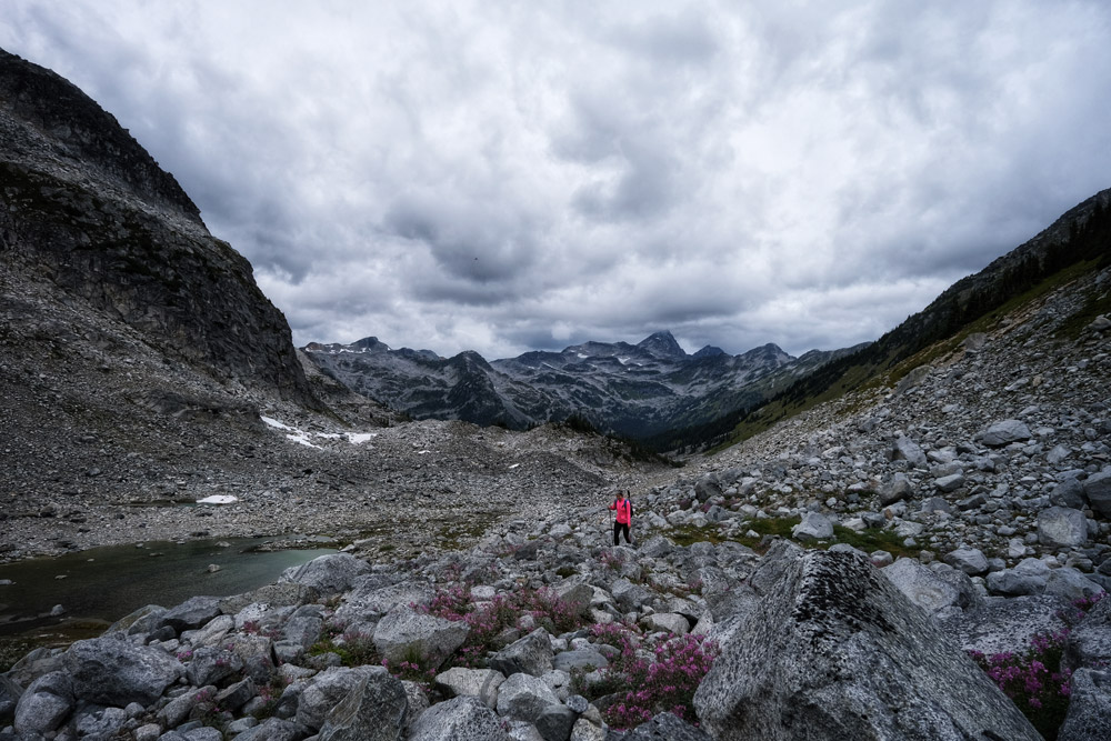
On our way up to the Mount Rohr Summit, the weather rapidly started to turn. Lake to Summit takes about 2.5 hours uphill through an unmarked boulder field.
We reached the top at about 2:30 pm… Once at the top, we could see dark clouds all around us covering nearby peaks, and the wind started really picking up. About halfway down from the summit back to Rohr Lake, we got into a real SNOW storm! That is in August!
Both of us had water-resistant clothing, but we did not have anything water-proof (other than our boots). So once closer to the Lake the snow became pouring rain, we got soaked quite quickly. Most of the campers were gone by then, so we decided to continue on down and back to our car.
I can tell you, hiking for 3 hours in pouring rain is NOT fun at all.
What made it more difficult, even dangerous, was the terrain. From the Rohr Lake down to the Marriott Road, it was all rocks, mud and slippery tree roots. The waterfall boulder wall was almost impassable in the rain. I mean, I was really seriously scared for my life climbing down. The only reason I survived it all in one piece: quality sturdy good grasp-soled high-ankle hiking boots and a pair of hiking poles. (more on hiking safety later)
Lesson learned: if there is even the slightest chance of rain on the day you plan to hike Mt Rohr – reschedule.
.
.
Hiking Safety
Hike to Rohr Lake and Mt Rohr is a difficult one that takes the full day. Past Pemberton – 30 min before you park for the trailhead – you will lose your phone reception. There is no cell reception anywhere along the hike too.
.
Bring a Friend
Do not hike Mt Rohr trail alone. You are looking at a full day complicated hike, whereas the second part – from Rohr Lake to Mt Rohr peak – will take you through a challenging boulder field with no trail markings. Always bring a hiking buddy to these types of hikes. It is simply common sense.
.
Tell a Friend
In addition to bringing a friend, tell someone else when and where you are going. As mentioned, you will lose phone reception about 30 min before you reach the Mount Rohr trailhead. Figure out the time by which you must “resurface”. Otherwise, if you did not text or call your friend by that time, instruct your friend to start raising an alarm with a local search and rescue team.
Personal Example:
When we did Mt Rohr hike, we planned to reach the trailhead by 9am. We calculated that we should be back to our carby 7-8pm. Yet, mostly due to anticipated beauty of Rohr Lake and plans to fly a video drone in the area (allowed!) we gave ourselves an “allowance” of extra two hours.
Our friend was instructed that if we do not resurface by 10pm, he should call 911 and tell them exactly where we were: he had our photos, photos of our car and license plate number, time we left on the trail, our exact planned route, etc. So all he had to do is, just give it all to the local search and rescue team.
We came back online at approx 7:30pm. All good! And, we felt super-safe knowing that someone is out there looking after us.
.
Leave a Note
Yeah… don’t count me as one of those safety-freaks, but I am a mother, and it is important for me to account for all the risks. So in addition to telling a friend and instructing him with all the details of our whereabouts, when venturing out into the wilderness I am always leaving a note on my dashboard.
My note usually says something like: “Hi, if you are reading this note, and today is [date], please alert search and rescue with the location of this car, and call this number [phone number of my friend, friend’s name]. We went hiking [name] trail, as per AllTrails Mobile Application.”
Date would be the next day after we were supposed to come back to the car.
Trail name: we write the exact name it is listed under in AllTrails Mobile App – as that is one of the most popular hiking apps and it is easy to see the exact hiking directions. (by the way, I strongly recommend AllTrails, if you don’t have it yet)
Example: We hiked Mt Rohr on August 30th.
My note said: “Hi, if you are reading this note, and today is August 31st, please alert search and rescue with the location of this car, and call this number [phone number of my friend, friend’s name]. We went hiking Mt Rohr via Marriott Basin Trail as per AllTrails Mobile Application, and were supposed to be back by end of day August 30th”
.
Bring Water to Mt Rohr Summit Hike
Simply put, there is no drinkable water past Rohr Lake. So if you decided to make it all the way to Mt. Rohr Summit, make sure to have plenty of water with you. From the lake to Mt Rohr summit and back will take you 4.5-5 hours.
If your plan is to stock-up on water at Rohr Lake – yet you’d need a proper water filtration system with you, like LifeStraw.

.
.
Shoes and Sticks
Mt. Rohr is one of the hardest hikes we have done to-date. 16.5 km hike with over 1km elevation gain, coming down from the summit during a sudden snowstorm, hiking back the boulder field in the freezing rain… …and scrambling the waterfall boulder wall through mud and slippery tree-roots was a total nightmare.
If not for my waterproof high ankle hiking boots, paired with a set of sturdy hiking poles – I do not think I would have made it in one piece.
Lesson learned: never underestimate hiking poles. Always take hiking poles with you.

.
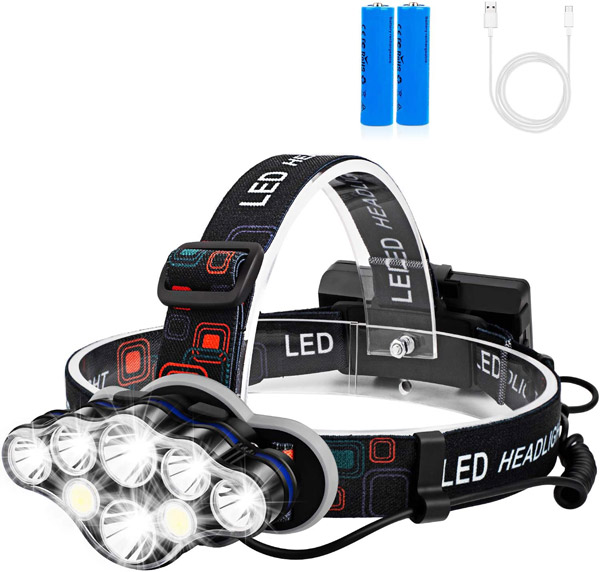
Light, Laser and Fire
The hike will take you 9-10 hours – plan the full day. You won’t want to be returning in the dark, especially you won’t want to climb that waterfall boulder wall in the dark. But stuff happens sometimes, and we have to plan ahead.
Pack a flashlight with you: the one that can be mounted on your forehead. Believe me, you will need both hands around the boulder field and the waterfall boulder wall on your way down from Rohr Lake.
.
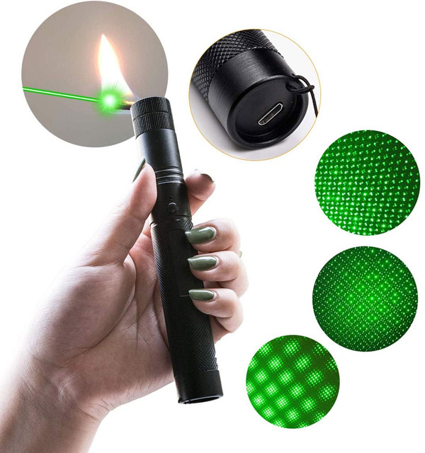
Bring along a laser light. Laser light can be seen through large distances, and even reach out into the sky. In case something happens you will be better off signaling for help.
Pack a lighter and know how to start a fire. In case it does get dark, and you find yourself still up around the Rohr Lake unplanned, look around for campfires. There are a good number of campsites around and you may find other hikers spending the night at Rohr Lake. Regardless, at an empty campsite you may find leftover firewood, and as long as you have a lighter, you will be able to get yourself warm. It does get very cold at night up in this area even in the summer due to elevation – Lake Rohr is at approx 1,800 metres.
.
Mt Rohr Hike Bear Safety
The area around Joffre Lakes, Mt Rohr, and Duffey Lake Provincial Park is a well known grizzly territory. Luckily, we haven't met any bears along Mt Rohr trail. Yet, you never know! Therefore you have to follow a few safety rules around here:
- Do not bring smelly foods with you. All snacks should be properly packaged in air-sealed bags.
- Make noise when hiking – talk, sing, bring bear bells
- Bring your bear spray – the red one.
Here is a quick video on how to purchase bear spray in British Columbia, Canada:
Other Hiking safety tips you may find useful:
- Leave No Trace & Outdoor Ethics – Zero Impact Family Adventures
- Social Distancing Outdoors Rules: Responsible Hiking During The Pandemic
- Hiking With Kids: 12 Simple Safety Rules Every Parent Should Follow
- Best Hiking Shoes For Kids Complete Guide: How to Choose and Where to Buy
.
Mount Rohr Conclusion
Considering the difficulty level and the challenges we have experienced along the way, was the hike to Mt Rohr worth it? Absolutely!
We believe it is when you survive through the challenges together and get to that summit, and proudly look around from the top of the world – that is the sense of achievement that makes life worth living.
We hope that our notes and tips are going to be useful if you decide to take-up the challenge and conquer Mt Rohr yourself.
Have you been to Mount Rohr and hiked the trail already? Tell us all about your experience in comments!
You may also like:
- Joffre Lakes Trail: Practical Guide to Successfully Hiking Most Popular BC Alpine Park
- Breathtaking Waterfall Hike – Full Guide – Crooked Falls Near Vancouver
- Top Family Winter Activities & Eco-Friendly Things To Do in Whistler, Canada
- Mt. Edith Cavell Meadows trail & Angel Glacier hike on Jasper, Alberta family road trip
.
Don’t miss out on the new exciting outdoor adventures in Beautiful British Columbia or anywhere else in the World! Sign-up for our newsletter!
.
Stay safe, strong and healthy. Everything else will come.
.
Enjoy!
Cheerfully yours,
Alexandra, Alex & Cosmos
.
Share your pictures on social media! tag #PerfectDayToPlayHike to be featured on our Instagram!
.
You May Also Like

Leave a Comment

| We are so happy you are reading our Outdoors & Travel Blog! We are an adventurous family from British Columbia, Canada exploring the World, sharing exceptional family experiences, while helping others to travel with kids and to live a joyful, healthy, eco-friendly and sustainable lifestyle. We believe in making memories every single day! Cheerfully yours, Alexandra, Alex and Cosmos |


37 Baby Stroller Friendly Hiking Trails Every Vancouver Mom Should Visit
10 Crowd-free Easy Hiking Trails in Vancouver: Social Distancing Outdoors
60++ Hilarious Hiking & Camping Memes You Absolutely Have To See
Best Kids-Friendly Swimming Lakes Near Vancouver | PerfectDayToPlay

Haleakala Secret Spot To Enjoy Crowd-Free Speechless Hawaii Sunset

Secrets to Writing Hotel Reviews Like a Professional Travel Blogger

100+ Hilarious Road Trip Memes & Cartoons - Truth About Family Travel
Five Tried-And-True Outdoor Activities To Get Kids to Absolutely Love Hiking

What To Do With An Old Baby Car Seat? How to Recycle Car Seat?


Blog Comments
80++ Hilarious Hiking & Camping Memes You Absolutely Have To See
April 28, 2022 at 10:37 pm
[…] have… Our Grand Canyon Rim-to-river-to-Rim Hike in Arizona US in 2015, and more recent Mt. Rohr, BC Canada in 2020 hike are still painful to […]
Where to find Belarus People in Canada? Belarusian Diaspora explained.
April 21, 2022 at 3:10 am
[…] Freedom Flag at Mt Rohr, British Columbia, […]
Best Kids-Friendly Swimming Lakes Near Vancouver | PerfectDayToPlay
April 11, 2022 at 11:24 pm
[…] Rohr Lake near Pemberton, BC – swimming is allowed, yet the lake is hard to access – it requires a 2.5-hour hike that is not kids-friendly. […]
Joffre Lakes Trail: Practical Tips to Hiking Popular BC Alpine Park
April 11, 2022 at 11:23 pm
[…] Mt Rohr Hike: the Unexpected Discovery. Hard yet Absolutely Rewarding! […]